Our Historic Public Right-of-WayWhere in Kensington do you live? It might seem like an odd question, especially if you are new to the neighborhood, but Kensington is actually composed of several different subdivisions, each mapped and built out at different times. In each subdivision are various historic objects in the Public Right-of-Way (PROW) that contribute to our understanding of the history of how Kensington developed and how its residents lived.
Kensington Park, the oldest subdivision, was first mapped in April 1910. Kensington Park was bounded by Terrace Drive on the west and County Road (now 42nd Street) on the east, and Jefferson Avenue (now Alder Drive) on the north and Monroe Avenue on the south. When Kensington Park was “opened” by agent William Douglas for the sale of lots on Thanksgiving Day, November 25, 1910, there was little more than dirt sidewalks and the streets laid out, with cobblestone pillars marking the boundaries of the subdivision.
A year later, on the
anniversary of the “grand opening”, Douglas was trumpeting the improvements made in Kensington, including “cement sidewalks and curbs. Absolutely the best street grading in San Diego. There shade trees are growing the entire length and breadth of Kensington.”
“There you will find great entrance gates.
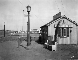
Electric light posts on every corner.“
Almost one hundred years later, the original light posts are gone, and only one
original cobblestone entry pillar remains in its original location, at the south-east corner of Edgeware Road and Monroe Avenue. Other entry pillars have been relocated and rebuilt at the corners of Monroe and Terrace Drive,
Madison Avenue and Terrace Drive, and at Adams Avenue as you first enter Kensington from the bridge.
It’s doubtful that any original cement sidewalk remains, but as you walk around, notice that the sidewalks vary in pattern and color. Sidewalks were poured at varying times in sections, and at the end of each section the name of the
sidewalk contractor and the year it was installed is stamped. These sidewalk stamps have become a sort of collector’s item, and help tell the story of the growth of our little village. You can still see the original name of Madison Avenue,
Mission Drive, stamped in the sidewalk on the northeast corner of the intersection of Edgeware Road.
In the
Kensington Manor subdivision, north of Alder Drive to approximately Hilldale Road, the
original street lamps are still located throughout the neighborhood. The same
decorative street lamps can be found in the Talmadge Park subdivisions, around East Alder Drive and Talmadge Circle. Look around for a few
sidewalk stamps here and there. Many have disappeared from the ends of the stretch of sidewalk when ADA-compliant wheelchair ramps were installed, but a
few can still be found in the middle of the block, or where there are rounded corners with no street access.
In Kensington Heights, the historic lamp posts change to a distinctive
“crown” style globe, found nowhere else in San Diego, but found in Pasadena.